New files in: 1 day, 3 days, 7 days, 30 days
| Most downloaded for: all time,
year,
half a year,
month,
two weeks,
three days
Most popular by rating | Submit a file
Most popular by rating | Submit a file
| Folder: |
Air Crash Investigation
| Rating: 5!

On 30 June 1956, United Airlines Flight 718 and Trans World Airlines Flight 2 collided over the Grand Canyon in Arizona. All 128 occupants on both flights were killed. At the time, it was the deadliest airline crash in history, and would lead to sweeping changes in the regulation of flight operations over the United States.
→ Filename:
→ Date:
11 years ago (05.09.2013 15:46)
→ Author:
National Geographic
→ Approved by moderator:
AirArt
→ License:
Freeware - Free version, Do Not Redistribute

On 7 September 2011, a Yakovlev Yak-42D, carrying the Lokomotiv Yaroslavl professional ice hockey team, crashed on take-off at the Volga River, near Yaroslavl, Russia. Out of the 45 occupants, only one survived.
→ Filename:
→ Date:
11 years ago (19.07.2013 11:04)
→ Author:
National Geographic
→ Approved by moderator:
SLAVJAN
→ License:
Freeware - Free version, Unlimited Distribution
Maxim Gorkiy - History of the Giant Aircraft
| Rating: 5!

The book is the first full telling of the most unusual airplane in the world - giant propaganda plane "Maxim Gorky" and its modifications. The publication is richly illustrated with many photographs published for the first time. The book is intended for a wide range of readers interested in the history of Soviet aviation.
→ Size:
45 MB
→ Date:
14 years ago (27.08.2010 12:23)
→ Author:
М. Б. Саукке
→ Approved by moderator:
Jhenya
→ License:
Freeware - Free version, Unlimited Distribution
→ Downloaded:
355 time(s)
CJ-27 World Aeronautical Chart
| Rating: 5!
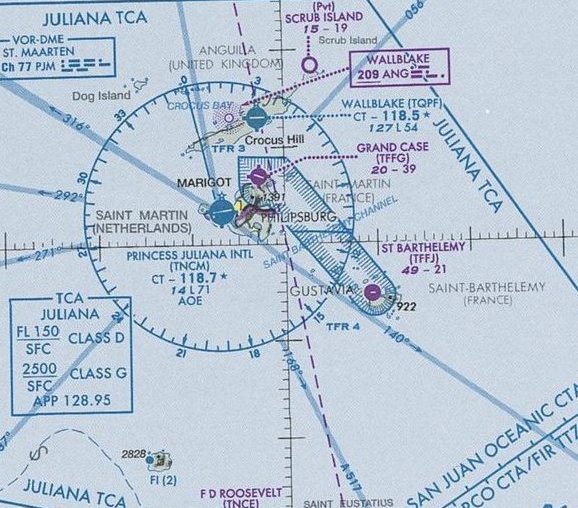
Map in JPEG format 7965x5488. Covers islands such as Hispaniola, Caicos, Saint Martin, Guadeloupe, and others in between. Valid until 5 April 2012
→ Size:
8 MB
→ Date:
14 years ago (14.07.2010 06:42)
→ Author:
FAA
→ Approved by moderator:
Lenya69
→ License:
Freeware - Free version, Unlimited Distribution
→ Downloaded:
502 time(s)
CJ-26 World Aeronautical Chart
| Rating: 5!
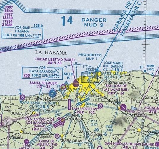
Map in JPEG format 7931x5452. Covers Cuba, Jamaica, and parts of Haiti and the Bahamas. Valid until 9 February 2012
→ Size:
9 MB
→ Date:
15 years ago (26.04.2010 07:06)
→ Author:
FAA
→ Approved by moderator:
seric76
→ License:
Freeware - Free version, Unlimited Distribution
→ Downloaded:
463 time(s)
Detroit Helicopter Chart
| Rating: 4!
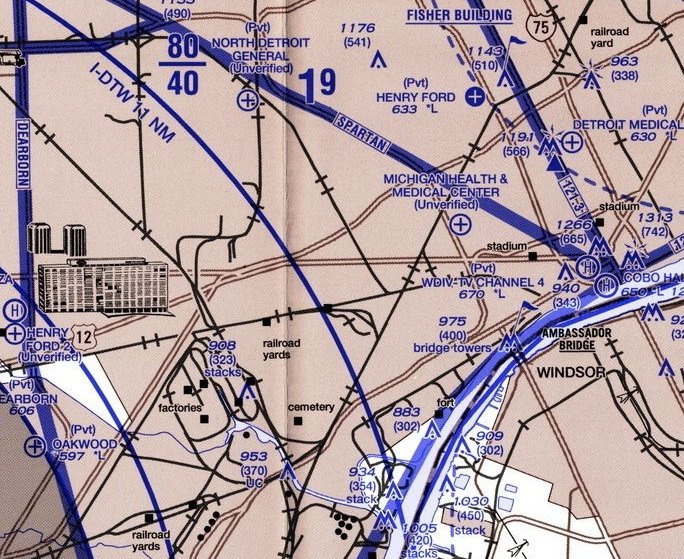
Map in JPEG format 6031x4041. Covers Detroit City and suburbs. 1st Edition: Aug 4 2005.
→ Size:
6 MB
→ Date:
15 years ago (20.04.2010 14:01)
→ Author:
FAA
→ Approved by moderator:
Aleks_Balagur
→ License:
Freeware - Free version, Unlimited Distribution
→ Downloaded:
138 time(s)
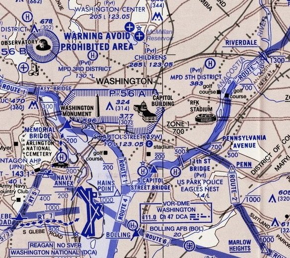
Map in JPEG format 5970x2652. Covers Washington DC/Northern Virginia and surrounding suburbs. Edition: 30 Jul 2009
→ Size:
5 MB
→ Date:
15 years ago (18.04.2010 11:18)
→ Author:
FAA
→ Approved by moderator:
UDVA
→ License:
Freeware - Free version, Unlimited Distribution
→ Downloaded:
177 time(s)
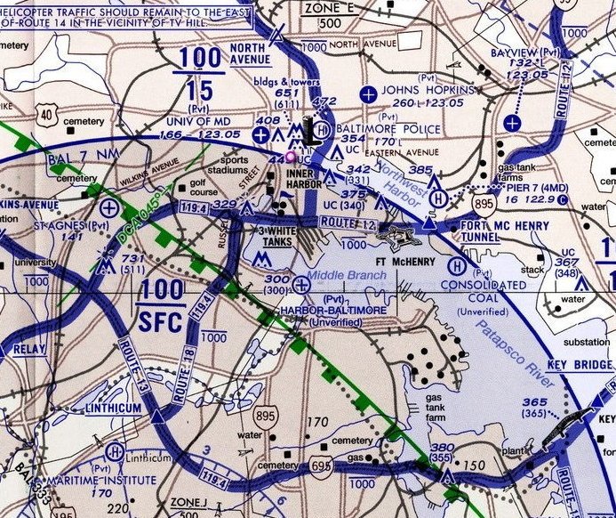
Map in JPEG format 5286x2645. Covers Baltimore city and suburbs. An insert chart also covers Washington downtown.
→ Size:
4 MB
→ Date:
15 years ago (18.04.2010 11:18)
→ Author:
FAA
→ Approved by moderator:
UDVA
→ License:
Freeware - Free version, Unlimited Distribution
→ Downloaded:
125 time(s)
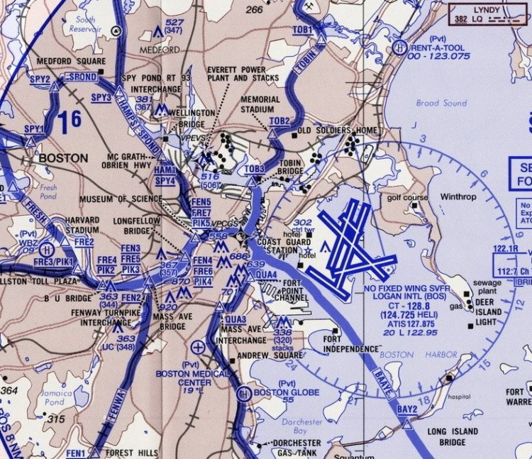
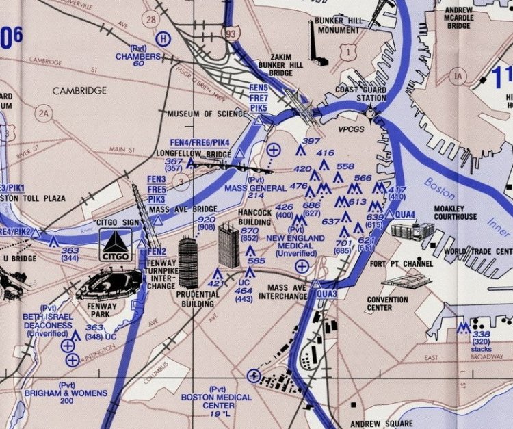
Map in JPEG format 4677x3877. Covers City of Boston and adjoining suburbs. Edition: 20 Dec 2007
→ Size:
4 MB
→ Date:
15 years ago (03.04.2010 10:51)
→ Author:
FAA
→ Approved by moderator:
UDVA
→ License:
Freeware - Free version, Unlimited Distribution
→ Downloaded:
128 time(s)
Map in JPEG format 6010x4013. Covers New York City and adjacent suburbs. Edition: 19 Nov 2009
→ Size:
6 MB
→ Date:
15 years ago (03.04.2010 10:22)
→ Author:
FAA
→ Approved by moderator:
UDVA
→ License:
Freeware - Free version, Unlimited Distribution
→ Downloaded:
202 time(s)
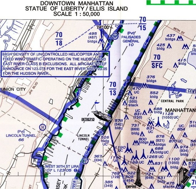
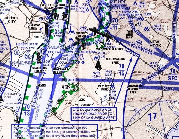
Map in JPEG format 3364x1989. Covers central Manhattan and neighboring areas. Edition: 19 Nov 2009
→ Size:
2 MB
→ Date:
15 years ago (03.04.2010 10:22)
→ Author:
FAA
→ Approved by moderator:
UDVA
→ License:
Freeware - Free version, Unlimited Distribution
→ Downloaded:
209 time(s)
VFR8 (Ukraine) Sectional Chart
| Rating: 5!
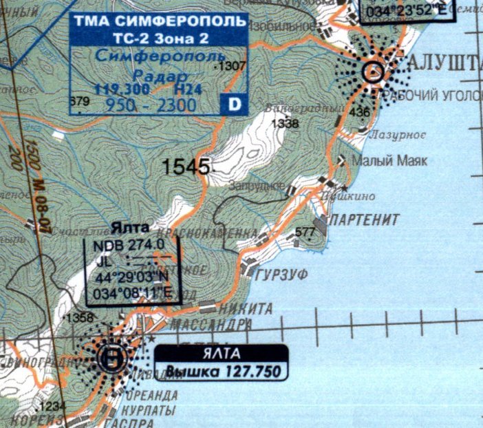
Map in JPEG format 10446x7826. Covers southern part of Ukraine. Simferopol', AR Krimea. Edition: 7 May 2009.
→ Size:
12 MB
→ Date:
15 years ago (15.12.2009 12:04)
→ Author:
САІ України
→ Approved by moderator:
omega
→ License:
Freeware - Free version, Unlimited Distribution
→ Downloaded:
897 time(s)
VFR7 (Ukraine) Sectional Chart
| Rating: 5!
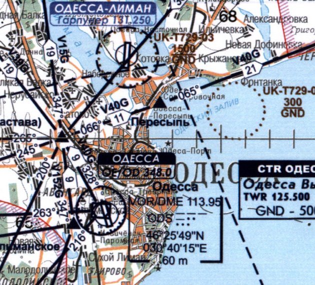
Map in JPEG format 10424x6059. Covers southern part of Ukraine: Izmail, Odessa, Mykolaiv, Kherson, and in between. Edition: 7 May 2009.
→ Size:
17 MB
→ Date:
15 years ago (15.12.2009 08:29)
→ Author:
САІ Украіни
→ Approved by moderator:
omega
→ License:
Freeware - Free version, Unlimited Distribution
→ Downloaded:
815 time(s)
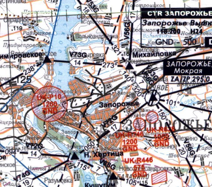
Map in JPEG format 10411x6046. Covers southeast part of Ukraine: Dnipropetrovs'k, Zaporizhzhia, Donets'k, Luhans'k, and in between. Edition: 7 May 2009.
→ Size:
18 MB
→ Date:
15 years ago (15.12.2009 08:29)
→ Author:
САІ Украіни
→ Approved by moderator:
omega
→ License:
Freeware - Free version, Unlimited Distribution
→ Downloaded:
780 time(s)