Набор РНК Аляски Просмотр ZIP-архива
Alaska/Sectionals Readme.txt
Sectional Charts of the Unites States Textures
Calibrated for use in FSM MovingMap by Rana Hossain
By Matt Fox
[email protected]
February 2005


Introduction:
================================================================

This set of textures have been designed to work with FSM Moving Map by Rana Hossain (http://www.ranainside.com/software_flightsim_movingmap.html).  They should also be easy to set up for other moving map programs.

These are different than the Sectionals I uploaded in 2004.  The 2004 maps will not work in FSM Moving Map.

Any questions, please ask in the FSM Moving map forum at http://www.ranainside.com.

Special thanks to Rana Hossain for making FSM Moving Map and working to get it to import my files directly.


Installation:
================================================================

Installation is simple.  Just put the images and their associated files into a folder, run FSM Moving Map, Go to the screen where maps are imported and use the Mass Import function.  They will automatically be set up and calibrated.  FSM Moving Map might look like it freezes for a minute or two during the import.  Just be patient and it will work.

If you are also using my Terminal Area Charts for the United States, these will automatically load and replace the Sectional textures when your aircraft enters the area covered by the  TAC.  In order to make sure this happens correctly, use the Weight feature of FSM Moving Map to make sure the TACs have a higher Weight value than the Sectionals.  You can modify them all at the same time using the "Mass Update" function of FSMMM.


Converting Images to GIFs:
================================================================
The images have all been converted to JPGs to make their sizes reasonable.  Converting them to GIF format will increase the size of each file but seems to decrease the amount of RAM required to process the images.  I think this is because JPGs are 32 bit color and GIF is only 256 color.  From what I've seen JPGs can use 5 to 10 times the amount of RAM compared to GIFs.

Irfanview is a free image viewer that can batch convert the files from JPG to GIF.  You can find it here http://www.irfanview.com/

To do the batch conversion, just run Irfanview and hit the B key.   Then click on the Advanced Options button and make sure Resize is not checked.  Also check the "Change Color Depth" box and select Custom and enter 64 colors.  The fewer colors, the smaller the file.  64 colors should be plenty for these maps.

DO NOT change the resolution of the images or they won't work in FSM Moving Map.

Known Issues:
================================================================
The airplane might not line up on the map exactly where it shows in FS.  It should be very close though.

The closer you get to the poles, the more the images will appear distorted.  For example, a round circle might appear as an oval.  This is due to the reprojection of the images.


Disclaimer:
================================================================
Obviously, these files are intended for simulation use only.  Anyone that uses these for real world navigation is an idiot and shouldn't be flying in the first place.  I am in no way responsible for any damage or losses, real or virtual, caused by use of these files.  Use at your own risk.

These files are freeware and can be used for any non-commercial use.  I will only upload these to www.avsim.com, but give my permission to upload them to other websites so long as you keep this original readme file with them.
44935-alaska-sec.zip
| Имя файла | Дата | Размер |
|---|---|---|
| Alaska/ | 30.05.2012 22:13 | |
| Alaska/Anchorage.jpg | 20.09.2005 19:56 | 6 MB |
| Alaska/Fairbanks.jpg | 20.09.2005 20:13 | 9 MB |
| Alaska/Point Barrow.jpg | 20.09.2005 21:22 | 4 MB |
| Alaska/Sectionals Readme.txt | 28.02.2005 05:17 | 4 KB |
| Alaska/US_SEC_ANCHORAGE EAST.JGW | 28.02.2005 03:08 | 156 B |
| Alaska/US_SEC_ANCHORAGE EAST.jpg | 28.02.2005 03:08 | 3 MB |
| Alaska/US_SEC_ANCHORAGE EAST.prj | 28.02.2005 03:08 | 149 B |
| Alaska/US_SEC_ANCHORAGE WEST.JGW | 28.02.2005 03:02 | 156 B |
| Alaska/US_SEC_ANCHORAGE WEST.jpg | 28.02.2005 03:02 | 3 MB |
| Alaska/US_SEC_ANCHORAGE WEST.prj | 28.02.2005 03:02 | 149 B |
| Alaska/US_SEC_BETHEL EAST.JGW | 28.02.2005 03:20 | 156 B |
| Alaska/US_SEC_BETHEL EAST.jpg | 28.02.2005 03:20 | 3 MB |
| Alaska/US_SEC_BETHEL EAST.prj | 28.02.2005 03:20 | 149 B |
| Alaska/US_SEC_Bethel WEST.JGW | 28.02.2005 03:18 | 156 B |
| Alaska/US_SEC_BETHEL WEST.jpg | 28.02.2005 03:18 | 3 MB |
| Alaska/US_SEC_Bethel WEST.prj | 28.02.2005 03:18 | 149 B |
| Alaska/US_SEC_COLD BAY.JGW | 28.02.2005 04:57 | 156 B |
| Alaska/US_SEC_COLD BAY.jpg | 28.02.2005 04:57 | 2 MB |
| Alaska/US_SEC_COLD BAY.prj | 28.02.2005 04:57 | 149 B |
| Alaska/US_SEC_DUTCH HARBOR EaST.JGW | 28.02.2005 04:55 | 156 B |
| Alaska/US_SEC_DUTCH HARBOR EaST.jpg | 28.02.2005 04:55 | 1 MB |
| Alaska/US_SEC_DUTCH HARBOR EaST.prj | 28.02.2005 04:55 | 149 B |
| Alaska/US_SEC_DUTCH HARBOR WEST.JGW | 28.02.2005 04:53 | 156 B |
| Alaska/US_SEC_DUTCH HARBOR WEST.jpg | 28.02.2005 04:53 | 920 KB |
| Alaska/US_SEC_DUTCH HARBOR WEST.prj | 28.02.2005 04:53 | 149 B |
| Alaska/US_SEC_JUNEAU EaST.JGW | 28.02.2005 04:17 | 156 B |
| Alaska/US_SEC_JUNEAU EAST.jpg | 28.02.2005 04:17 | 4 MB |
| Alaska/US_SEC_JUNEAU EaST.prj | 28.02.2005 04:17 | 149 B |
| Alaska/US_SEC_JUNEAU WEST.JGW | 28.02.2005 04:15 | 156 B |
| Alaska/US_SEC_JUNEAU WEST.jpg | 28.02.2005 04:15 | 2 MB |
| Alaska/US_SEC_JUNEAU WEST.prj | 28.02.2005 04:15 | 149 B |
| Alaska/US_SEC_KETCHIKAN EAST.JGW | 28.02.2005 03:26 | 156 B |
| Alaska/US_SEC_KETCHIKAN EAST.jpg | 28.02.2005 03:26 | 2 MB |
| Alaska/US_SEC_KETCHIKAN EAST.prj | 28.02.2005 03:26 | 149 B |
| Alaska/US_SEC_KETCHIKAN WEST.JGW | 28.02.2005 03:24 | 156 B |
| Alaska/US_SEC_KETCHIKAN WEST.jpg | 28.02.2005 03:24 | 1 MB |
| Alaska/US_SEC_KETCHIKAN WEST.prj | 28.02.2005 03:24 | 149 B |
| Alaska/US_SEC_KODIAK EAST.JGW | 28.02.2005 04:48 | 156 B |
| Alaska/US_SEC_KODIAK EAST.jpg | 28.02.2005 04:48 | 3 MB |
| Alaska/US_SEC_KODIAK EAST.prj | 28.02.2005 04:48 | 149 B |
| Alaska/US_SEC_KODIAK WEST.JGW | 28.02.2005 04:46 | 156 B |
| Alaska/US_SEC_KODIAK WEST.jpg | 28.02.2005 04:46 | 2 MB |
| Alaska/US_SEC_KODIAK WEST.prj | 28.02.2005 04:46 | 149 B |
| Alaska/US_SEC_MCGRATH EAST.JGW | 28.02.2005 04:34 | 156 B |
| Alaska/US_SEC_MCGRATH EAST.jpg | 28.02.2005 04:34 | 3 MB |
| Alaska/US_SEC_MCGRATH EAST.prj | 28.02.2005 04:34 | 149 B |
| Alaska/US_SEC_MCGRATH WEST.JGW | 28.02.2005 04:33 | 156 B |
| Alaska/US_SEC_MCGRATH WEST.jpg | 28.02.2005 04:33 | 2 MB |
| Alaska/US_SEC_MCGRATH WEST.prj | 28.02.2005 04:33 | 149 B |
| Alaska/US_SEC_SEWARD.JGW | 28.02.2005 04:43 | 156 B |
| Alaska/US_SEC_SEWARD.jpg | 28.02.2005 04:43 | 980 KB |
| Alaska/US_SEC_SEWARD.prj | 28.02.2005 04:43 | 149 B |
| Alaska/US_SEC_Western Aleutian Islands EAST.JGW | 28.02.2005 04:08 | 156 B |
| Alaska/US_SEC_Western Aleutian Islands EAST.jpg | 28.02.2005 04:08 | 1 MB |
| Alaska/US_SEC_Western Aleutian Islands EAST.prj | 28.02.2005 04:08 | 149 B |
| Alaska/US_SEC_Western Aleutian Islands WEST.JGW | 28.02.2005 03:42 | 156 B |
| Alaska/US_SEC_Western Aleutian Islands WEST.jpg | 28.02.2005 03:42 | 2 MB |
| Alaska/US_SEC_Western Aleutian Islands WEST.prj | 28.02.2005 03:42 | 149 B |
| Alaska/US_SEC_WHITEHORSE EAST.JGW | 28.02.2005 04:25 | 156 B |
| Alaska/US_SEC_WHITEHORSE EAST.jpg | 28.02.2005 04:25 | 3 MB |
| Alaska/US_SEC_WHITEHORSE EAST.prj | 28.02.2005 04:25 | 149 B |
| Alaska/US_SEC_WHITEHORSE WEST.JGW | 28.02.2005 04:24 | 156 B |
| Alaska/US_SEC_WHITEHORSE WEST.jpg | 28.02.2005 04:24 | 2 MB |
| Alaska/US_SEC_WHITEHORSE WEST.prj | 28.02.2005 04:24 | 149 B |
| YCTAHOBKA.txt | 30.05.2012 22:40 | 2 KB |
| Sectionals Readme.txt | 28.02.2005 05:17 | 4 KB |
| avsim_su.diz | 31.05.2012 01:16 | 406 B |
| Итого: | 62 MB | |
Набор РНК Аляски
| Rating: 5!
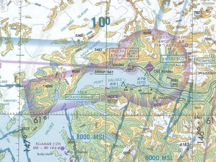
Набор РНК Аляски. Карты 2005 года, но для полетов в оффлайне, а может даже и в онлайне (не проверял), подойдет. В данный архив включены все регионы Аляски. Кроме того карты уже настроены для интеграции в программу FSMMoving Map 1.2. Все карты в расширении *.jpg, *.prj и *.jgw.
Инструкция по установке в FSMMoving Map в архиве.
Инструкция по установке в FSMMoving Map в архиве.
→ Size:
60 MB
→ Date:
14 years ago (30.05.2012 23:53)
→ Author:
→ Approved by moderator:
Anton_G
→ License:
License file included in archive
→ Downloaded:
759 time(s)