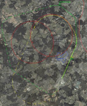
Overlay of two schemes of landing UUWW, VPP19 (20) and old (1998-2006) and new (in force 11.02.2010) on a satellite image in high resolution. Yellow painted old system, green - new. Red - the no-fly zone. Hopefully, it will be interesting to simmerov, Spotters and residents in the area. Beware, Jpeg large - 36 mb, the size in pixels 10576 x 12872
→ Size:
36 MB
→ Date:
16 years ago (02.02.2010 16:44)
→ Author:
DAR
→ Approved by moderator:
Lenya69
→ License:
Freeware - Free version, Unlimited Distribution
→ Downloaded:
771 time(s)
5
Class, that's my problem on a map of the old scheme almost before the third razvorotom.Skolko can remember planes do not always follow this scheme, particularly the height (600-1500 meters in the eye) And until about 1998 the scheme was even closer to the Ring Road. The latter scheme is generally PPC.
− Swarm,
15 years ago,
#
Absolutely true drew:) It was over my house and goes. As soon as the southern breeze, the joy comes in the house, and neighbors hang:)
− SheV,
16 years ago,
#
DAR and not share the information where the shot was pumped?
− SheV,
16 years ago,
#
Yandex-map, there is like everywhere in the image Yandex logo looms)))
− DAR,
16 years ago,
#
Thank you! Choi is not made out of logos:)
− SheV,
16 years ago,
#
historical variation in the sense
− DAR,
16 years ago,
#
5
Interesting. And for Runway 06-24 is?
− spectr,
16 years ago,
#
it's all there in the circuits of the airport, for the 06-24 range of standard
− lockon,
16 years ago,
#
Yes it is clear that the schemes are all the same I have all the schemes and draw, with reference to geokoordinatam.'s interest simply to visually see the "over how the house runs through Sunset," and that in the center of the exclusion zones:))) runway 24 will describe later, may there is one scheme or a variation? someone special, help pliz)
− DAR,
16 years ago,
#