New files in: 1 day, 3 days, 7 days, 30 days
| Most downloaded for: all time,
year,
half a year,
month,
two weeks,
three days
Most popular by rating | Submit a file
Most popular by rating | Submit a file
| Folder: |
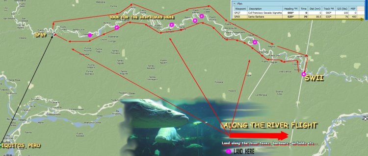
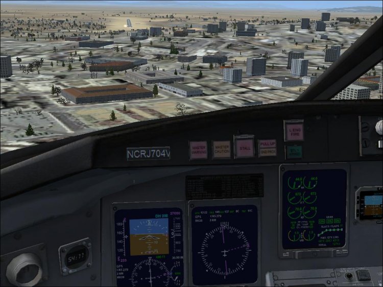
Scenery and Flights...The arapaima, pirarucu, or paiche (Arapaima gigas) is a South American tropical freshwater fish. It is a living fossil and one of the largest freshwater fishes in the world. Arapaima can reach lengths of more than 2 m (6.6 ft), in some exceptional cases even more than 2.5 m (8.2 ft) and over 100 kg (220 lbs). The maximum-cited weight for the species is 200 kg (500 lbs). Dr. Amaud Fontain of the Paris Fish Foundation has prepared an expedition leaving from Iquitos in Peru and flying one of the Amazon?s many affluents where this great fish have been seen. Perico del Monte, a local fisherman will fly with the Expedition to the spots where he fishes these monsters. He has assured the Dr. that there are species as large as ten feet and with a weight of over 600 kilos!!!!!. This scenery plus the added flight will engulf the pilot in an unparalleled adventure in one of the most mysterious river on earth...the Amazonas!!!( Flight prohibited to amateur pilots due to the high dangers!)
→ Size:
3 MB
→ Date:
16 years ago (08.05.2010 01:58)
→ Author:
Gera Godoy Canova
→ Approved by moderator:
Lenya69
→ License:
Freeware - Free version, Do Not Redistribute
→ Downloaded:
347 time(s)
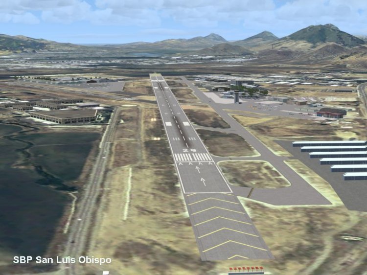
This landscape covers the California coast region of N36 10 '(Coalinga) at N34 25' (Santa Barbara) and from the shore of the East to W119 40 '. It's - version of my previous California Central Coast landscape reworked and expanded to work with the Earth MegaScenery from PC Aviator Inc. and netting 9.6m Localities FSGenesis U.S. FSX V2 Justin Tyme. Many airstrips in the area covered by this scenery added or expanded for a total of 27 airports / airstrips in the area. 6 imaginary water runways are also added to the variable motion plane AI. Several areas of interest such as the Marina Santa Barbara, Bay Morro, etc. also included for a total of 41 interesting questions. All airports, runways, and linked structures adapted and rebuilt to match the actual positions and dimensions as specified satellite textures MegaScenery. MegaScenery California-13, -14 and -15 are necessary for the landscape to make sense. I also used the California-12, -28 and -29 in creating the landscape but they could be considered complementary. I have purchased CA-12 as the transition from the CA-13, to violate commitments cuts right through the Hearst Castle, plus CD-12 includes Hunter Liggett and Big Sur. CA-28 will add 1 more than the airport and 3 runways, plus Priest VOR / RCAG. CA-29 adds 4 runways, plus PRB ARSR. None of these three are not significant but they fill the region CCC good. I found that many built-in airports and airstrips in the area of CCC were not accurately identified and are aligned on the AC. In this landscape, which are fully adjusted to agree with the real world as displayed MegaScenery.
→ Size:
8 MB
→ Date:
16 years ago (26.04.2010 05:06)
→ Author:
Неизвестно
→ Approved by moderator:
UDVA
→ License:
Freeware - Free version, Unlimited Distribution
→ Downloaded:
1221 time(s)

Moderately detailed landscape VFR airfield Turkey Trabzon LTCG, the surrounding area and the city of Trabzon, in the eastern Black Sea region of Turkey, mainly made through the Instant Messenger software landscape for FSX (SP2). Landscape Landscape made by a Moment, SbuilderX, Earth FS Up, FSX SP2 SDK (Commentator) Project and editor Airport. Contains realistic positioning of objects and autogen, also has some of the components of photoreal textures (with kind permission of Google). Landscape is made through a landscape of objects and autogen so you can see the details of how your "complexity Landscapes as and setting the density Autogen "should be alt least TIGHT. To see the texture photoreal, you must have your" solution Textures "setting on 60cm max (preferebly 7cm). Objects - embedded objects FSX.
→ Size:
66 MB
→ Date:
16 years ago (26.04.2010 05:05)
→ Author:
Неизвестно
→ Approved by moderator:
UDVA
→ License:
Freeware - Free version, Unlimited Distribution
→ Downloaded:
2261 time(s)
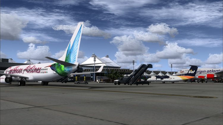
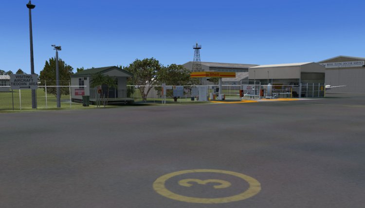
Airport Grantley Adams International (ICAO: TBPB), found in Seawell, Christ Church on the south side of the island of Barbados. Located 8 miles from the main city of Bridgetown and reacted to 1930. It - a site for most major airlines in the eastern Caribbean Sea and was the location of British tourists and airlines for some time and because of this - the status as a former British colony, the British have a lot of residences here and it became known as the playground for the rich and famous . In such an extent that Barbados was one of the locations for British Airways concorde, which runs daily flights from London for some years. Aviation Concorde G-BOAE - now a permanent display in the new museum "Experience Barbados Concorde" to the east the main area.
→ Size:
70 MB
→ Date:
16 years ago (26.04.2010 03:26)
→ Author:
Max Kraus
→ Approved by moderator:
seric76
→ License:
Freeware - Free version, Unlimited Distribution
→ Downloaded:
3173 time(s)

This landscape includes 3 airports that are located in central Queensland, Australia. Airports - Longreach, Barcaldine and Rockhampton. This landscape contains photoreal backgrounds and this is mixed in with textures payware FTX.
→ Size:
52 MB
→ Date:
16 years ago (26.04.2010 02:31)
→ Author:
Неизвестин
→ Approved by moderator:
Lenya69
→ License:
Freeware - Free version, Unlimited Distribution
→ Downloaded:
539 time(s)
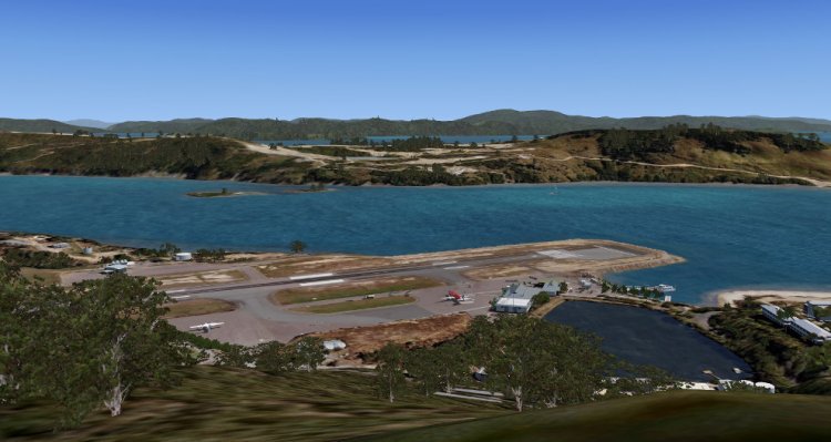
Hamilton Island is part of the Trinity Islands eastern shore of Queensland, Australia. The Island is used almost exclusively for tourism with many resorts. The island leased from the Commonwealth Goverment Oatley family and who has worked most businessed and accommodation on the island. The airport was created in most of the restored land and has a single runway 14/32, which - 1764m (5788 ') long (long). Ever want to know what it is like planting a big plane on an aircraft carrier? Well now you can find. No exceedances also the end of the runway. Rejection and you finish in the water. The wind usually blows from the south east, so that the runway 14 gets the most use (as you can see tire marks). Jetstar and Virgin Blue service the A320's and B737's from Brisbane, Melbourne and Sydney. During the school holidays B767's, is known to run the route. Another move could include private aircraft as flying in a rich, to enjoy their holiday homes or some of the more exclusive resorts. There are a number of helicopters based on the Isle of Hamilton, serving as scenic flights. General aviation less common. The last time I checked that the connection fees were down about $ 120 a night!
→ Size:
57 MB
→ Date:
16 years ago (26.04.2010 01:38)
→ Author:
Благодарю вас Jgruschow, aussiecop, frostlp, Алан, Mitchell W, VH-WCE, IW11, Dwho, tommyg, groundwolf, Matt_Webb, Butch
→ Approved by moderator:
Lenya69
→ License:
Freeware - Free version, Unlimited Distribution
→ Downloaded:
1598 time(s)
Islands, Elliot is the southern most island in the Great Barrier Reef. Great Barrier Reef extends along the coast of Queensland and the majority - the world's largest coral reef system. Lady Elliot Island is a privately own island and is the resort. Stop middle of the island - 600 meters of the runway (2000 '). You'll also find two lighthouse on the island. New, high lighthouse was built as trees on the island have grown so much that they began to block the light from more than the old lighthouse. The easiest way to reach the island - through the air or from the Bay or Bundaberg Hervey. Seair Serves daily flights to the island, benefiting from Britten Norman Islanders, Dual otter and Caravan Cessna. Visit aussiex.org website where you can download its color for Aerosoft Twin Otter and Caravan embedded in the colors of Air Seair / Lady Elliot. I loved the effect, which adds to the sound of waves and birds on the Island Lady Elliot. If you do not love the sound effect that you can remove it by removing the file "Addon SceneryAnts Aussie AirportsSceneryaaa8_LadyElliotIs_OceanNoise.bgl".
→ Size:
54 MB
→ Date:
16 years ago (26.04.2010 00:21)
→ Author:
Kris Robinson
→ Approved by moderator:
smart32
→ License:
Freeware - Free version, Unlimited Distribution
→ Downloaded:
803 time(s)
Another scenario is suffering Sochi, this time for FSX. Airport staff is made of Sochi, the only differences in the systems PAPI (present in all WFP) and sunset on the GPS. Set in the simulator is the same as in my previous Aeroportovskiy works.
→ Size:
9 KB
→ Date:
16 years ago (25.04.2010 15:48)
→ Author:
Виталик Цимух (Leardjet45)
→ Approved by moderator:
UDVA
→ License:
Freeware - Free version, Unlimited Distribution
→ Downloaded:
4676 time(s)
Khmelnitsky airport
| Rating: 5!
Revised script airport Khmelnitsky (Ukraine). Added runway lighting system VASI, jet refill visits and GPS Runway 16 and 34. Installation: Extract both files in Scenery / Global / Scenery and try to get pleasure from landing -:))
→ Size:
3 KB
→ Date:
16 years ago (24.04.2010 17:04)
→ Author:
Виталик Цимух (Leardjet45)
→ Approved by moderator:
NetHunter
→ License:
Freeware - Free version, Unlimited Distribution
→ Downloaded:
882 time(s)
Western Africa Freight Service (Episode 1)
| Rating: 5!
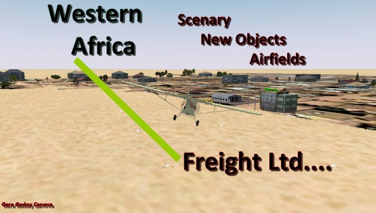
A 1965 Freight Company that covered the Western Part of Africa. Several flights will take you from Casablanca in Morocco to many Western Africa Airports and some out of the way airfields and International Missions. Many flights are enclosed as well as Original Scenery Objects, Afcads, Airfields, Weather , Maps and probable weeks of entertaining Flights in the Dark Continent.
→ Size:
2 MB
→ Date:
16 years ago (06.04.2010 22:56)
→ Author:
Gera Godoy Canova
→ Approved by moderator:
isc
→ License:
Freeware - Free version, Do Not Redistribute
→ Downloaded:
1009 time(s)
Revised script Uzhgorod
| Rating: 4.7!
Revised script a / p Uzhgorod (Ukraine). As is known, staff Uzhgorod in the simulator is very poor and difficult to land (there is only runway 10/28 with no parking zone, to the same runway 28 displaced threshold by as much as 1,765 feet, which is not in reality). This kit is actually a revised Uzhgorod with a normal runway, parking area and a GPS approach runway 10/28. Installation: Extract both files in Scenery / Global / Scenery. Have a nice flight.
→ Size:
3 KB
→ Date:
16 years ago (06.04.2010 19:31)
→ Author:
Виталик Цимух (Leardjet45)
→ Approved by moderator:
SLAVJAN
→ License:
Freeware - Free version, Unlimited Distribution
→ Downloaded:
732 time(s)
Kirovograd Sity - Airport's
| Rating: 5!
This archive airports glorious city of Kirovohrad (Ukraine) with the official instrumental approaches. Now the manager will start your flight for ILS or GPS. PSPrinoshu sorry for the bad quality of a / b Kirov (in an area of difficult terrain that does not allow properly execute a substrate of the airport).
→ Size:
87 KB
→ Date:
16 years ago (28.03.2010 01:33)
→ Author:
Виталик Цимух (Leardjet45)
→ Approved by moderator:
isc
→ License:
Freeware - Free version, Unlimited Distribution
→ Downloaded:
859 time(s)
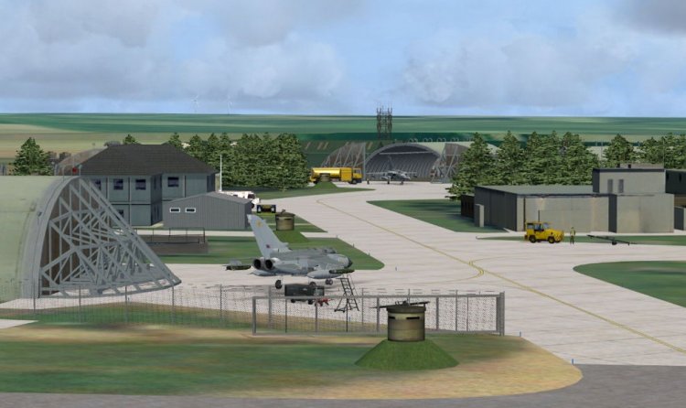
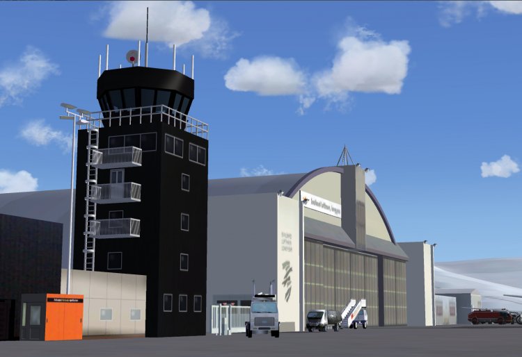
RAF Marham
| Rating: 5!
Baltiysk-2
| Rating: 5!
Scenery of Baltiysk, Kaliningrad and region
→ Size:
3 MB
→ Date:
16 years ago (23.03.2010 19:26)
→ Author:
Дмитрий Борисович Штефанов aka dmi-shef, Сергей Иванов aka Scorpio9999
→ Approved by moderator:
omega
→ License:
Freeware - Free version, Unlimited Distribution
→ Downloaded:
1861 time(s)
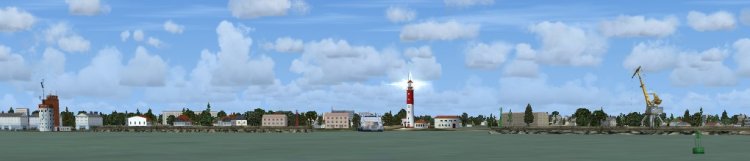
Svalbard (ENSB), Spitzbergen
| Rating: 5!
Svalbard, Spitsbergen is a land of contrasts. An outpost in the high
arctic wilderness, it is home to advanced high-tech operations. While polar
bears roam the provincial capital Longyear (Longyearbyen), close by the
satellite ground station complex “Svalsat” is host to NASA, ESA and the
Japanese Space Agency. More recently (2008) the Global Seed Vault was
constructed in Longyear’s permafrost, a secure storage facility designed to
preserve examples of the Earth’s plant seeds. Coal mining and fishing have
been Svalbard’s major industries for decades.
→ Size:
5 MB
→ Date:
16 years ago (03.03.2010 02:19)
→ Author:
→ Approved by moderator:
Lenya69
→ License:
Freeware - Free version, Do Not Redistribute
→ Downloaded:
3395 time(s)