New files in: 1 day, 3 days, 7 days, 30 days
| Most downloaded for: all time,
year,
half a year,
month,
two weeks,
three days
Most popular by rating | Submit a file
Most popular by rating | Submit a file
| Folder: |
QFE plug-in for Euroscope v1.2
| Rating: 5!

Shows QFE heights in the vicinity of the airport. Allows to assign heights in meters below TH and flight levels in meters/feet above TH. Also shows QFE, transition level and control height in a separate window when METAR is updated (TL is calculated, or taken from charts, when specified).
→ Size:
59 KB
→ Date:
16 years ago (31.01.2010 21:12)
→ Author:
Сергей Зырянов
→ Approved by moderator:
Lenya69
→ License:
Freeware - Free version, Unlimited Distribution
→ Downloaded:
685 time(s)
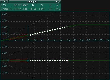
Adds landing aircraft list and precision approach radar to Euroscope.
→ Size:
73 KB
→ Date:
16 years ago (17.01.2010 22:45)
→ Author:
Сергей Зырянов
→ Approved by moderator:
Ramirezzz_x
→ License:
Freeware - Free version, Unlimited Distribution
→ Downloaded:
1680 time(s)
QFE plug-in for Euroscope v1.1
| Rating: 5!
Shows QFE heights in the vicinity of the airport. Allows to assign heights in meters below TH and flight levels meters/feet above TH. Also shows QFE, transition level and control height in a separate window when METAR is updated.
→ Size:
57 KB
→ Date:
16 years ago (09.01.2010 20:03)
→ Author:
Сергей Зырянов
→ Approved by moderator:
Lenya69
→ License:
Freeware - Free version, Unlimited Distribution
→ Downloaded:
384 time(s)
af2sct
| Rating: 5!
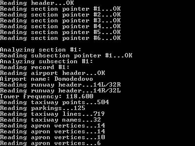
Program generates sector file for VRC, sector and ese files for EuroScope and MLSP settings from AFCAD bgl file of the airport.
→ Size:
81 KB
→ Date:
16 years ago (07.08.2009 20:05)
→ Author:
Сергей Зырянов
→ Approved by moderator:
Lenya69
→ License:
Freeware - Free version, Unlimited Distribution
→ Downloaded:
1003 time(s)
sctdraw 1.0
| Rating: 4.5!
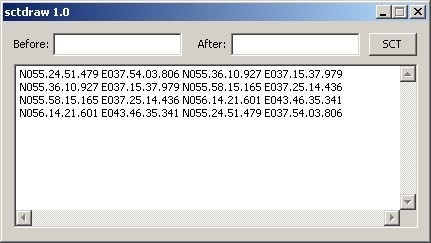
Sctdraw helps to get data for sector files (.sct & .ese) from JeppView and AFCAD. It grabs mouse coordinates and allows to draw points, lines and closed areas.
→ Size:
31 KB
→ Date:
17 years ago (16.06.2009 02:00)
→ Author:
Сергей Зырянов
→ Approved by moderator:
AirArt
→ License:
Freeware - Free version, Unlimited Distribution
→ Downloaded:
514 time(s)